
Research
Research Roadmap
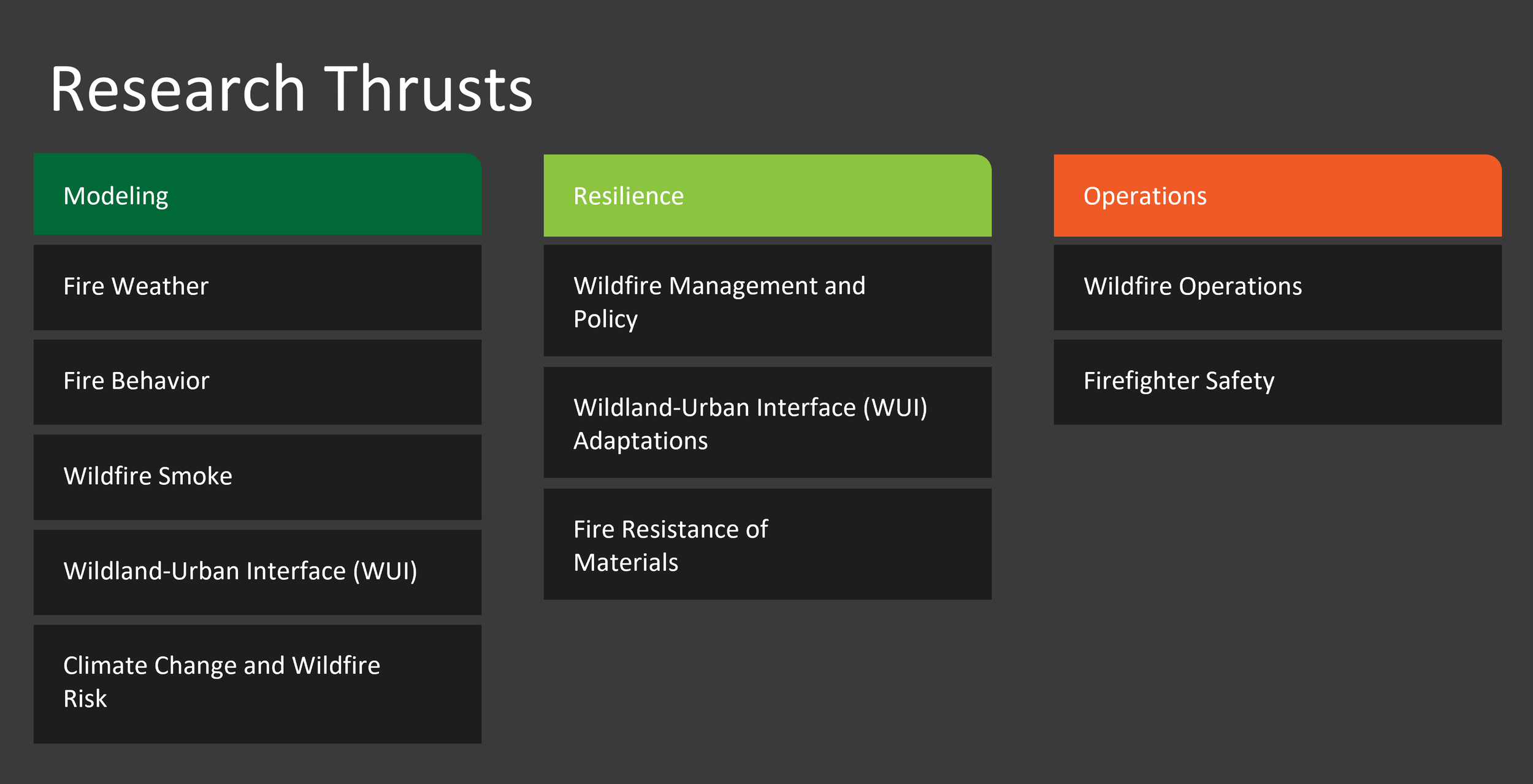
The WIRC Research Roadmap outlines our three main research areas and the specific thrusts within each research area. It graphically represents the current research direction for WIRC and is used to guide research funding decisions during our annual Industry Advisory Board (IAB) meeting.

Fire Weather
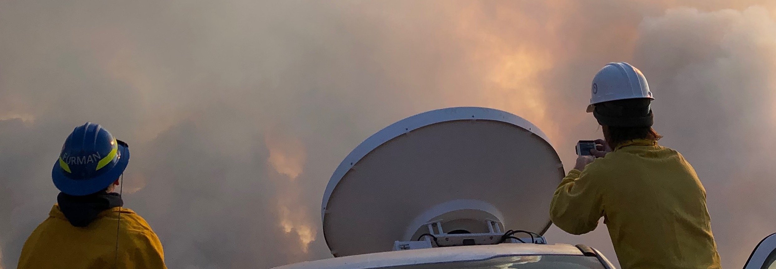
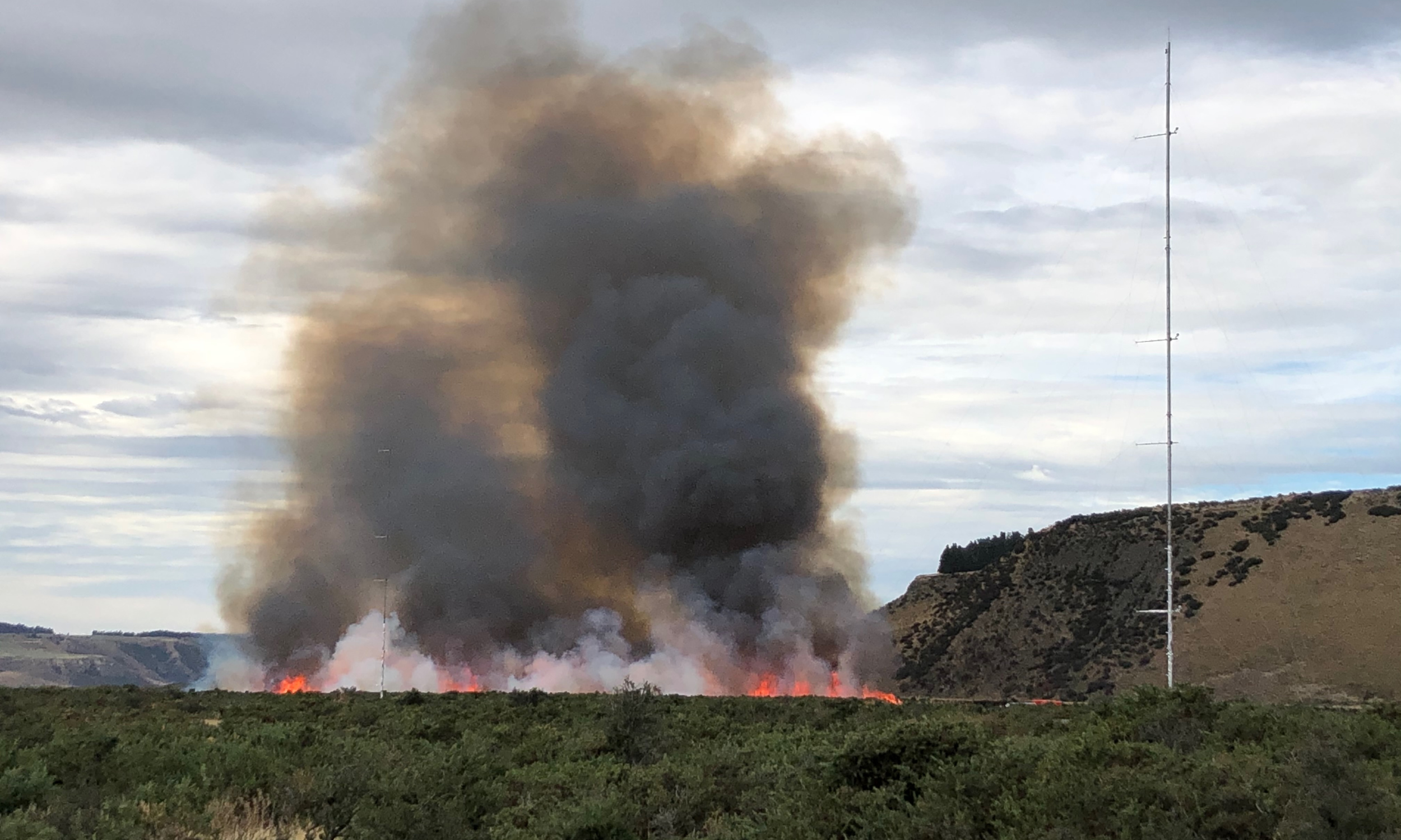
The Fire Weather Lab led by Dr. Clements conducts research on a number of problems related to fire weather and fire behavior. These include phenomena at the regional and mesoscales to microscale fire-atmospheric interactions at the fire front.
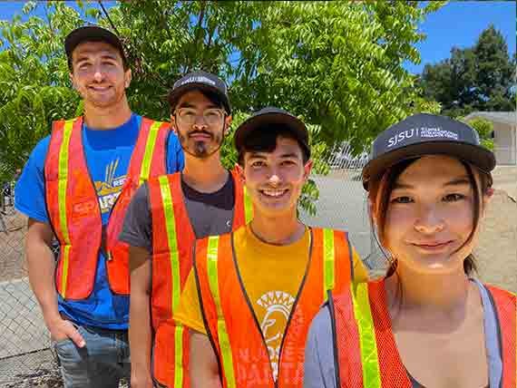
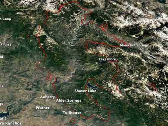
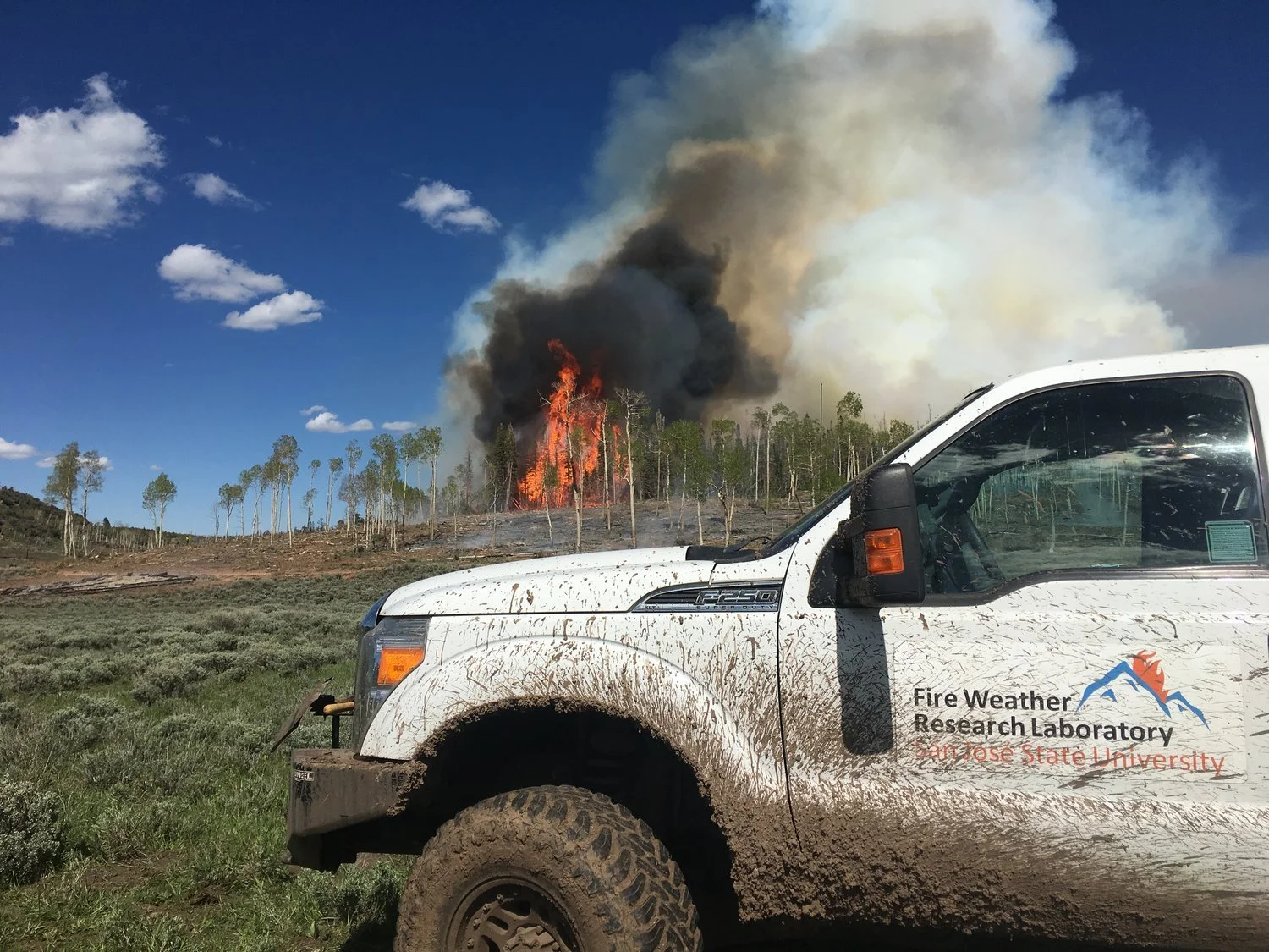
The Fire Weather Lab is an international leader in conducting field studies of fire-atmospheric interactions. We maintain a large set of data from various field campaigns conducted by our team and collaborators.

Fire Behavior
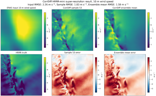
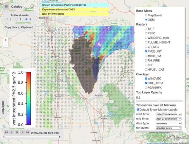
The fire modeling group is led by Dr. Kochanski and aims to advance our understanding of how wildfires create their own weather and impact air quality. The overarching goal of the WIRC modeling group is to improve current fire, smoke, and weather forecasting capabilities. We develop and run state-of-the-art forecasting and data assimilation systems based on the coupled fire-atmosphere model (WRF-SFIRE) to conduct numerical experiments and provide operational support for current wildfires and lay the groundwork for future weather, fire spread, and air quality models.
We feed supercomputers with weather data, satellite fire observations, airborne infrared fire perimeters, and fuel moisture to forecast future fire risk, fire progression, and smoke dispersion. We are a part of the Open Wildfire Modeling Group, gathering together developers of open-source wildfire models to help solve local and global wildfire problems.
We believe that using state-of-the-art fire models should be easy. We work with easy-to-use web-based solutions assisting in wildfire forecasting and prescribed burns. Numerical forecasts initiated from a web controller, are executed on a supercomputer, and uploaded to a web server where they are accessible from any device with an internet connection and a browser.

Wildfire Management and Policy
Practical wildfire science necessitates the intersection of diverse fields ranging from the social and behavioral sciences to the biophysical and technological sciences. Pressing issues are the restoration and management of fire-resilient landscapes, the creation of fire-adapted human communities, and ensuring safe and effective responses to wildland fire.
These aims represent an intersection of biophysical and social dimensions ranging from fire ecology and wildfire behavior to individual, group, and organizational (e.g., agency, industry) decision-making and policy innovations.
This research thrust examines the nexus of the social and biophysical contexts of wildfire management and adaptation across wildfire-prone landscapes. Members of the Center will focus on several research aims that work across fields related to human dimensions of wildfire science and fire ecology to inform wildfire and risk management.

Climate Change and Wildfire Risk
Wildfire characteristics are highly influenced by the background climatic environment in which they occur. Thus, it is inevitable that as the climate continues to change, characteristics of wildfires such as their favored locations, frequency, intensity, size and duration will change as well. In fact, long-term changes in wildfire activity have emerged as one of the most prominent impacts of climate change both through their direct effects on forests and infrastructure as well as through secondary effects like reduced air and water quality.
While it is well-established that changes in underlying climatic conditions affect wildfire activity through changes in weather (temperature, antecedent precipitation, relative humidity, windiness), fuel moisture, vegetation type, and lightning ignitions, there remains great uncertainty regarding the sign, magnitude, geography, and seasonality of those changes. Our work disentangles this multitude of influences and seeks to generate detailed information (in space, season, and through time) on the climatic influence on wildfires. This is accomplished via investigations of 1) the historical (empirical) relationships between various fire weather ingredients and wildfire activity; 2) through high spatiotemporal coupled land-atmosphere wildfire modeling and 3) through the incorporation of knowledge gained in 1 and 2 into existing projections of climate, vegetation and land-use change.

Wildland-Urban Interface (WUI) Modeling and Adaptation
The Wildland-Urban Interface (WUI) is the transition area between uninhabited land and human development. It is a barrier where people interact with undeveloped wildlands or vegetative environments, and where homes and associated structures are constructed in the vicinity of forests, shrublands, or grasslands. At the WUI, wildfires pose the greatest risk to houses and communities due to proximity of flammable vegetation. The Department of Fire Protection Engineering at Worcester Polytechnic Institute (WPI) is working to find mid- and long-term solutions for this problem. We propose and address the main factors as research topics for WIRC. It also should be noted that the engineering approaches developed at WPI will complement well and expand the research conducted at SJSU on the same topic, both for the social science aspects and the large-scale modeling of fire behavior and its interaction with the atmosphere.
Firefighter Safety
WUI fires pose a significant hazard to people (both firefighters and civilians), property (homes, cars, etc.) and natural/ecological resources (farms, ecosystems, etc.). For firefighters there is the acute threat of entrapment or being overrun by the fire as well as occupational risk of prolonged exposure to wildfire smoke and the resulting health consequences.
We seek to develop methodologies for better fire detection and monitoring, firefighters can be given greater situational awareness which can lead to less close calls with entrapment. This enhanced detection and monitoring could allow for faster and more effective response from the fire service, allowing their exposure to wildfire smoke (and associated health consequences) to be minimized. For property and natural/ecological resources, we will develop fire protection systems and autonomous/robotic firefighting solutions.
2026 Projects Funded by Our Industry Advisory Board
-
Climatology of Wind Gusts and Impacts on Fire Behavior and Risk
Principal Investigator:
Dr. Craig Clements
Institution(s): SJSU
-
AI Weather Framework for Wildfire Applications
Principal Investigator:
Dr. Angel Farguell
Institution(s): SJSU
-
Firebench Fire Models Inter-comparison and Systematic Benchmarking Framework
Principal Investigator:
Dr. Aurélien Costes,
Institution(s): SJSU & WPI
-
WUI fire exposure to structures from near-home combustibles: Firebrands, Flame Contact, & Radiation Year 2
Principal Investigator:
Dr. James Urban
Institution(s): WPI
-
Probabilistic Framework for Fire Risk Assessment using Fire Spread Models in FireBench: Year 1
Principal Investigator:
Dr. Reza Ziazi
Institution(s): WPI
-
Fuel Moisture Reanalysis Dataset of CONUS
Principal Investigator:
Dr. Angel Farguell
Institution(s): SJSU
-
Development of a Probabilistic Wildfire Risk Analysis Tool for Electrical Transmission Equipment: Phase I
Principal Investigator:
Dr. James Urban
Institution(s): WPI
-
Wildfire Data Exchange Platform
Principal Investigator:
Chase Porter
Institution(s): SJSU
-
Expertfluencers in Action: Mapping and Mobilizing Market Networks to Maximize Wildfire Risk Mitigation in Communities
Principal Investigator:
Dr. Amanda Stasieicz
Institution(s): University of Oregon
2025 Projects Funded by Our Industry Advisory Board

Pilot Study: Assessment of Soil Moisture Measurements and Linkages to FMC Observations

Home Ignition Zones: Building footprint, build year, and related codes

WUI fire exposure to structures from near-home combustibles: Firebrands, Flame Contact, & Radiation

Investigating Spot Fire Ignition of Natural Real Fuels from Hot Metal Particles

Firebench: Fire models inter-comparison and systematic benchmarking framework

Social vulnerability to PSPS: Scaling to Community to Highlight Local Capabilities and Quantify Industry Benefits

Motivating the mitigation market: mapping the market and characterizing mitigation profiles
2024 Projects Funded by Our Industry Advisory Board

Toward new data-driven fire spread modeling leveraging deep learning and novel high-performance computing solutions

Enhancing Community Fire Resilience Decision-Making: Drone Inspection for Home Ignition Zone

Developing a Sub-model for Spot Fire Growth in Wildland Fires

Fire models inter-comparison and systematic benchmarking framework

Codebase management for WIRC

The Impact of Climate Change on Extreme Fire Weather Risk in California for the near- and mid- 21st Century

Post-Wildfire Fuels Management using Multi-source Remote Sensing Approach

A Comprehensive Validation and Verification (V&V) Database for Wildfires
2023 Projects Funded by Our Industry Advisory Board


Research Groups


Observational Facilities
WIRC is located in the Department of Meteorology and Climate Science’s Arnold True Atmospheric Observatory on the top floor of the Duncan Hall of Science at San José State University and hosts the Fire Weather Research Laboratory.
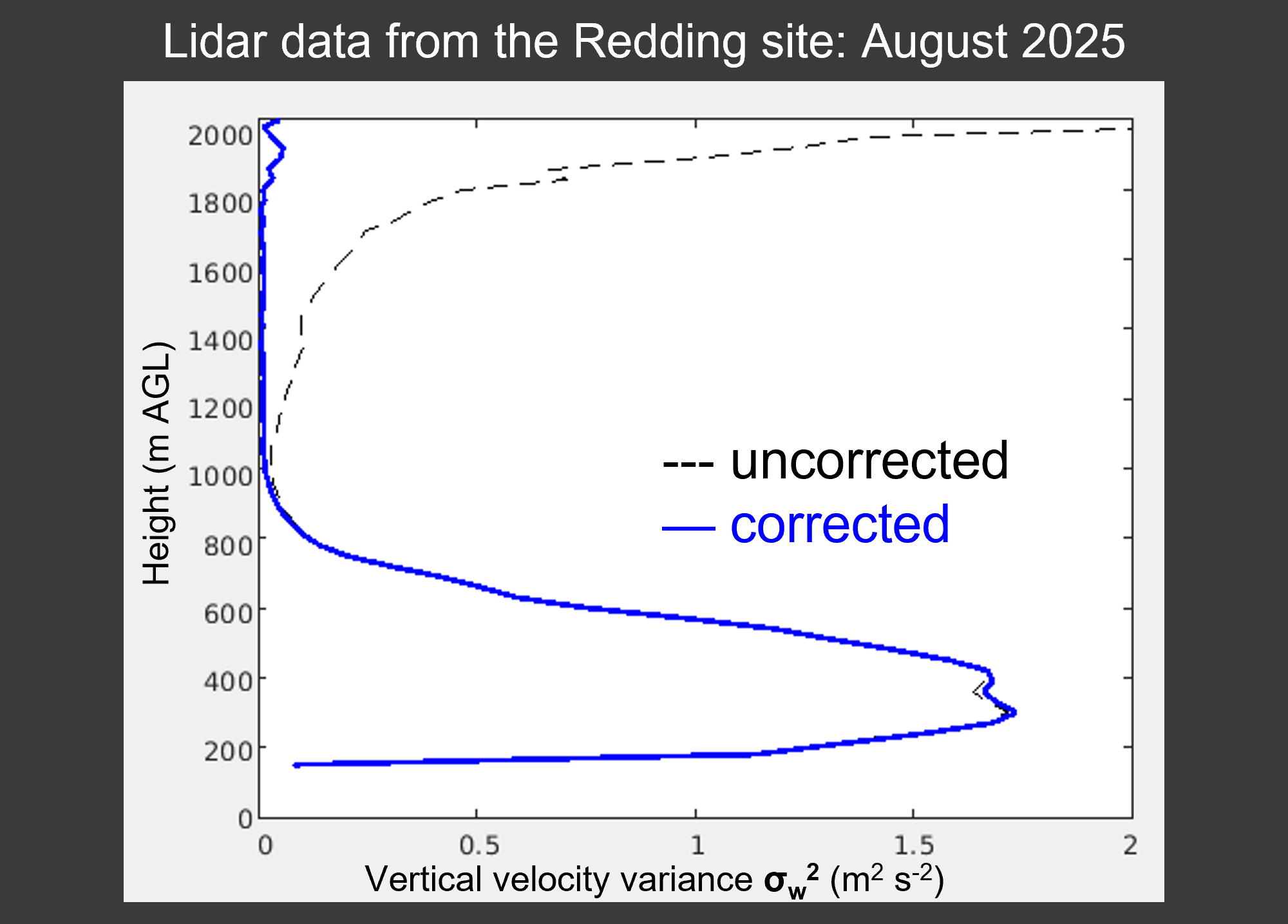
The Fire Weather Research Laboratory is the most well equipped fire weather research laboratory in the United States with a suite of assests including a network of remote fire weather stations, two 4×4 trucks equipped with Doppler lidar and radar, and an array of other laboratory facilities, sensor systems, and field equipment.
-

Mobile Ka-band Polarized Doppler Radar
The mobile Ka-band Doppler Radar is an amazing tool for the surveillance of wildfires and studying wildfire plume dynamics. The radar was built by Prosensing, Inc. and has a 20 deg/s scanning capability with 7.5 m range gate resolution. The radar acquisition was funded by the National Science Foundation and the truck was purchased by the College of Science.
-

Upper-air radiosonde systems
The lab currently operates four different radiosonde systems, GRAW GS-E, GS-H, Intermet, and a Vaisala DigiCora III. The GRAW systems have been used the most and are very reliable.
Radiosonde systems provide valuable information on the state of the atmosphere including winds, temperature, humidity, and most importantly, atmospheric stability. These radiosonde systems are used by the laboratory during both field experiments and active wildfire incidents.
-

Meteorological Equipment and Sensors
The lab is equipped with an extensive array of instrumentation to carry our elaborate field measurement campaigns including micrometeorological towers, upper-air soundings, and remote sensing of the boundary layer.
SJSU’s Doppler Sodar deployed in a mountain valley to measure vertical wind profiles.
Three dimensional ultrasonic anemometers are used to measure turbulence and winds within the fire environment during the fire front passage. The sonic anemometers have to be specially calibrated to be able to measure the high air temperatures associated with the fire plume.

Computing Facilities
The WIRC modeling group operates state-of-the-art computing resources hosted in the SJSU data center. They power coupled fire-atmosphere simulations as well as fire danger and fuel moisture estimates as well as data assimilation systems.
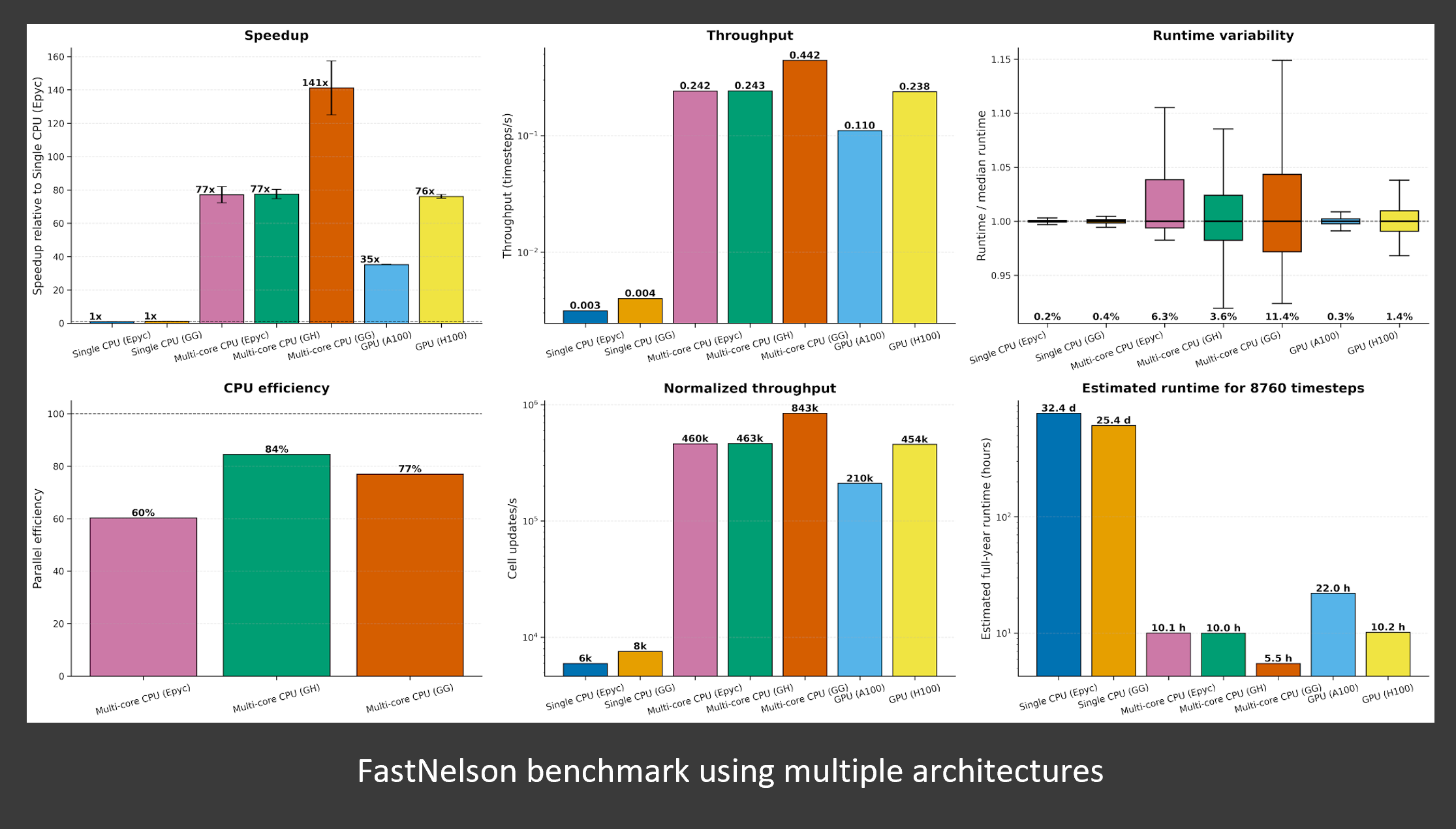
The main CPU-based Ember cluster supports the WRFx forecasting system run by the WIRC modeling group. It consists of 16 high-density compute nodes, a dedicated head node, and two data analysis nodes. Each compute node utilizes two AMD 7452 Epyc processors with 128MB cache, and 64 compute cores running at 2.35GHz, and 256GB-768GB of RAM. The head node utilizes two AMD 7302 Epyc processors (16 cores each) run at 3GHz. The cluster has the head node with NVIDIA Quadro RTX4000, and two dedicated data analysis GPU nodes with NVIDIA A100, 1TB of RAM, and two AMD EPYC 7302 16-core Processors run at 3GHz. Overall, the cluster offers 1024 compute cores in the compute partition, 32 cores in the head node, and 64 cores in the data analysis nodes (1120 cores total). The nodes are connected using InfiniBand fabrics to the Mellanox Quantum QM8790 – HDR InfiniBand switch offering up to 200Gbps interconnects. The head node and the compute nodes are connected to storage units with a total capacity of 1.7PB. Additionally, the cluster utilizes 310 TB of scratch disk space connected using a dual 10Gbps Ethernet link (20 Gbps).
The second cluster extends the basic Ember capabilities to support not only the CPU-based models but also heavy AI workloads and GPU applications. This one of the first of this kind clusters in academia leverages the newest NVIDIA GH200 Grace Hopper Superchips. The NVIDIA GH200 Grace Hopper Superchips combine the NVIDIA Grace and Hopper architectures using NVIDIA® NVLink®-C2C to deliver a CPU+GPU coherent memory model for accelerated AI and HPC applications. The cluster currently offers six GH200 nodes connected via 400Gbps InfiniBand fabric each providing 72 ARM CPUs and one H100 GPU. This machine supports the development and execution of AI-based rate of spread models, GPU-based fuel moisture and fire danger models, as well as CPU-based coupled fire-atmosphere simulations and forecasts. This cluster offers 432 Grace CPUs and six H100 GPUs.

Fire Dynamics Lab
The Fire and Fluid Dynamics Laboratory at the Mechanical Engineering department is undergoing an expansion to accommodate the Wildfire Dynamics Laboratory for WIRC. The laboratory will comprise a 1-2 MW burn room, a gas analyzer, 3D PTV and PLIF stations, and an extended bench-top combustion table. The facility will be equipped with cutting-edge data acquisition instruments, including an FTIR and high-speed and multi-spectral cameras. The primary objective of the combustion facility is to investigate the phenomenology of wildfires across various spatiotemporal scales and foster the education of the next generation of fire dynamics experts in California.

Geofly Drone Lab
The Geofly Drone Laboratory uses cutting-edge drone technology and geospatial science to advance wildfire research. Equipped with visible, multispectral, thermal, and LiDAR drones, the lab excels in gathering detailed environmental data. The integration of remote sensing, GIS, computer vision, and supercomputer computing allows for sophisticated analysis and interpretation of this data. In addition to research, the lab places a strong emphasis on STEM education, using drones and GIS to provide immersive learning experiences. This combination of high-tech equipment and advanced computational techniques positions the lab at the forefront of understanding and managing wildfire impacts through comprehensive fieldwork and analysis.